This is the training module for Drones Flying Near Me the instructor will give you a code to enable functionality.
This app will only function with the correct code.
IMPORTANT: This tool is used for training and your instructor will provide the code.
This app is a training tool which will allow analysts to demonstrate Remote ID to law Enforcement and people in the aviation community.
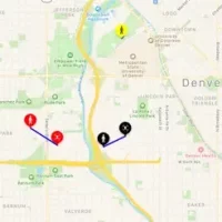
This app is a tool to educate both drone pilots and others about the upcoming FAA requirements around Remote ID. This app will simulate locating drones in the area and show them on the map.
Starting with version 1.4, the app, when running in Law Enforcement mode, will also look at changes in ground elevation so the reported altitude of the drone is much more accurate.
Comments will not be approved to be posted if they are SPAM, abusive, off-topic, use profanity, contain a personal attack, or promote hate of any kind.